Mount Outram
The hike up Mount Outram is decently long, with a nice Class 3 scramble at the end. This trip was a trip of many firsts - first overnight backpacking hike, first alpenglow, first hike in the Hozameen range, first time seeing so many stars in the night sky, and my first time witnessing another broski sprain their ankle on a hike. Let's just get right into it!
Finished writing: Aug 18, 2020
Park: E.C. Manning Provincial Park (technically just outside it)
Name of Hike: Mount Outram
Mountain Range: Cascade Mountains (subrange: Hozameen Mountains)
Elevation: 2461m
Distance: About 19-20km
Elevation Gain: 1821m according to AllTrails (started recording late, so I only tracked 1650m)
Below: My companions doing a little scrambling. We encountered a couple of false summits on our scramble, and I regret forgetting to take a snap of the true summit from one of the falsies.

Day 1
The trail is easy to find from the parking lot. I messed up and didn't start recording until about 20min into the hike, but you can see my trip up the mountain (over the two days) mapped below. I didn't track the way down this time.

We started off at the parking lot at around 10:20am. I was quite excited, as I was looking forward to tenting high up on the mountain and also seeing a little alpenglow. At the post in the second picture, you take a sharp left and head towards Mount Outram - you are actually leaving E.C. Manning Provincial Park (fortunately this means you don't need to purchase a backcountry camping permit, as you are outside the provincial park).


The first bit of the trail wasn't too steep, but I definitely felt the weight of the 85L backpack. I forgot my big sun hat at home, so I was very happy to be in the shade.

We stopped briefly for water at 11:10am at a little spot where we could see some mountains behind us. Just a few minutes later, we entered some nice mossy woods (seen in second picture).


At around 12:30pm, we came across a small stream (located at 49.270600, -121.167200) according to the photo location tag). We were able to filter some water from the stream on the way down on Day 2.

We had a bagel and cream cheese lunch around 1pm or so, and then we headed back up.
Pretty soon, the trail starts to become more of a climb. The packed dirt path becomes more rocky and loose. We felt that the lake couldn't be far but we had our hopes horribly crushed when we asked a man coming down how far the lake was and he responded that it was 40min away. At this point I could really feel the weight of the pack, and the combination of the sun on my hatless head and increased steepness gassing me out. I'm sure my huffing and puffing could have taken down all three little pigs' houses (woof woof!). We were a little stressed because someone we encountered had mentioned that there weren't many spots left at the top (it turns out there really isn't any shortage of camping spots).

We reached the lake around 2:30pm (about 4 hours from our start time). The rest of the day was spent hanging out and chilling in the lake area. I'm usually a fairly efficient day hiker and I don't usually take time to just chill, so it was an interesting change of pace for me.

I took a few steps in the lake - it's not really that deep, you can stand anywhere in the lake and have your head well above the water. The first couple metres have some rocks, but the rest is really soft (feels nice on the feet). The temperature is quite nice (i.e. not cold) as well. I would have gone in, but I didn't bring extra underwear or shorts!
My companions were incredibly shocked to see the critically endangered axolotl (indigenous to Mexico) in the lake halfway up Mount Outram (I am a pleb and I didn't know what an axolotl was). When we got home, we discovered that salamander larvae look a lot like axolotls and that alas, no groundbreaking discovery had been made. Here's a look at that badboy anyways:

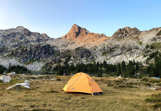
I got my one sock a little wet when I was getting into the lake (stepped in damp dirt), but this gave me the opportunity to explore the area barefoot! Below, you can see our tents as evening was falling. We had a nice warm rice, veggie and bean meal, and I learned how to play President around this time.
As I mentioned before, I had been looking forward to finally seeing the much talked about alpenglow. Well, here it is broskis - let's start with the iPhone pictures. You can see the alpenglow on Silvertip Mountain (right side) looks quite nice.


I took these DSLR pictures a little later when it got dark, and they captured the redness of the sky much better in my opinion:


Before night fell, we had a nice warm cup of peppermint hot chocolate (who knew that was a thing?).
I took the following picture when it was getting dark. You can see the first star of the night sky below. I know that the picture was taken looking south, so I looked up the night sky that night on Stellarium, and I'm pretty sure (not fully certain, but close) that the star pictured (the little white speck) is Antares.

I saw a single shooting star (could be my first cause I honestly don't recall seeing any at an earlier point in my life) and others saw several that night. I don't know if I can recall a time that I've seen more stars in the night sky. I had the best sleep I've ever had tenting - it was my first time using a sleeping pad and I can't tell you how great it felt to not have my shoulder blades dig into the cold hard ground.
Day 2
We physically left our tents around 8am, but the warm, bright sun had us up much earlier. Below, you can see Marmot Mountain on the left and Silvertip Mountain (the big peak on the right side).

We ate a nice warm oatmeal breakfast, got some water, and headed off on the trail a little after 9:30am. The trail is somewhat steep here, but our well rested legs didn't have too much trouble.

Eventually, we reached some scree. There are a lot of rocks spray painted red to mark the trail, and also some pink flag markers for the same purpose. The picture below was taken at 10:30am.

By 10:45am, we had reached the top. We started the trek towards the true summit. From here, there isn't much elevation gain, just a lot of scrambling up and down to get to the true summit. Overall, the scrambling wasn't too bad, but I struggled a little bit with visibility at a couple of sections, but not for the reasons you might expect. Before starting off that morning, I used one of the bags used for the tent and fashioned a little Lawrence of Arabia style headcovering since I didn't have a hat, but it blocked my peripheral vision. My camera bag was hanging by my waist, which meant I couldn't see as well below me, so downclimbing was certainly interesting.


We stopped just short of the true summit for a little while to eat our lunch (Nature Valley Roasted Almond and Apple Crisp crunchy granola bars and apples) and then headed off again.

Below you can see my broski making it through the what is probably the crux of the scramble. It is a little exposed here (you can't see too well in the picture, but it's a little narrow patch of dirt and a steep decline on either side) but not too bad as long as you go nice and slow.


We got to the true summit just before noon. We were happy because we were able to spend a reasonable amount of time at the summit (had we done this in a day, we would have been rushed). There isn't room for that many people, so we were lucky!
You can see Mount Baker in the distance during a lot of the hike, but I got an especially good picture at the peak (see picture below). I looked it up on PeakVisor and it turns out it is 75km away from Mount Outram! And as usual, I also took a video.


Below, you can see the probable crux again. I took a close up in the second pic - you can't see the drop on either side so it looks like a trivial drop, but it is slightly non-trivial.

Back to the scree:

In the second picture below, you can see a second lake in the distance (top left)!


Looking back up the mountain:

We got back to the lake around 2pm and then after a bagel and apple with some questionable cream cheese, we hit the trail at 2:30pm.
Disaster struck when we were about 3km or so away from the trailhead. My brother from another (or perhaps the same?) mother sprained his ankle pretty badly. It was a really random freak accident, no one really knew what exactly happened. Here is a reconstruction.
I sort of just watched in surprise while the third member of our trio got him ibuprofen (I was fresh out of fenty otherwise I would have totally hooked him up). My broski put the stuff from his backpack in hers, and I took his mostly empty backpack and wore it as a frontpack and we started off again at a slow and steady pace. Luckily, I had brought my trekking poles, and they came in handy for the sprained ankle. By the way: I am just kidding about the fenty.

We were back at the parking lot by about 5:15pm (about 3 hours to get down from the lake).
Overall, it was a very fun trip - I hadn't really done a long hike in the E.C. Manning area, and I had been eying Mount Outram for a while, so I'm glad I was able to cross it off my list. I was really lucky to have companions who provided all the food and gear. I'm sad that the trip ended on a somewhat less than ideal note, but I know my broski will make a speedy recovery!


Comments
Post a Comment