Black Prince Mountain and Lucifer Peak
I was planning one last trip of the season, and I wanted to do an solo overnighter, and after some deliberation I decided to go to the Valhallas again. Holy crap did I make the right decision! Lucifer and Black Prince are well worth the trek. The views were spectacular, the peaks were peak-y, and I met many a fellow broski on my journey! I also made it through a fairly sketchy backpack situation and a decently big storm.
Finished writing: Oct 11, 2020
Park: Valhalla Provincial Park
Name of Hike: Gwillim Lakes, Black Prince Mountain, Lucifer Peak
Mountain Range: Selkirk Mountains (subrange: Valhalla, subsubrange: Devils)
Elevation: 2742m (Black Prince), 2726m (Lucifer)
Distance: Approximately 25km (according to TopoMaps+ app)
Elevation Gain: ~800m (to Gwillim Lakes), 850m (from Gwillim Lakes to both peaks)

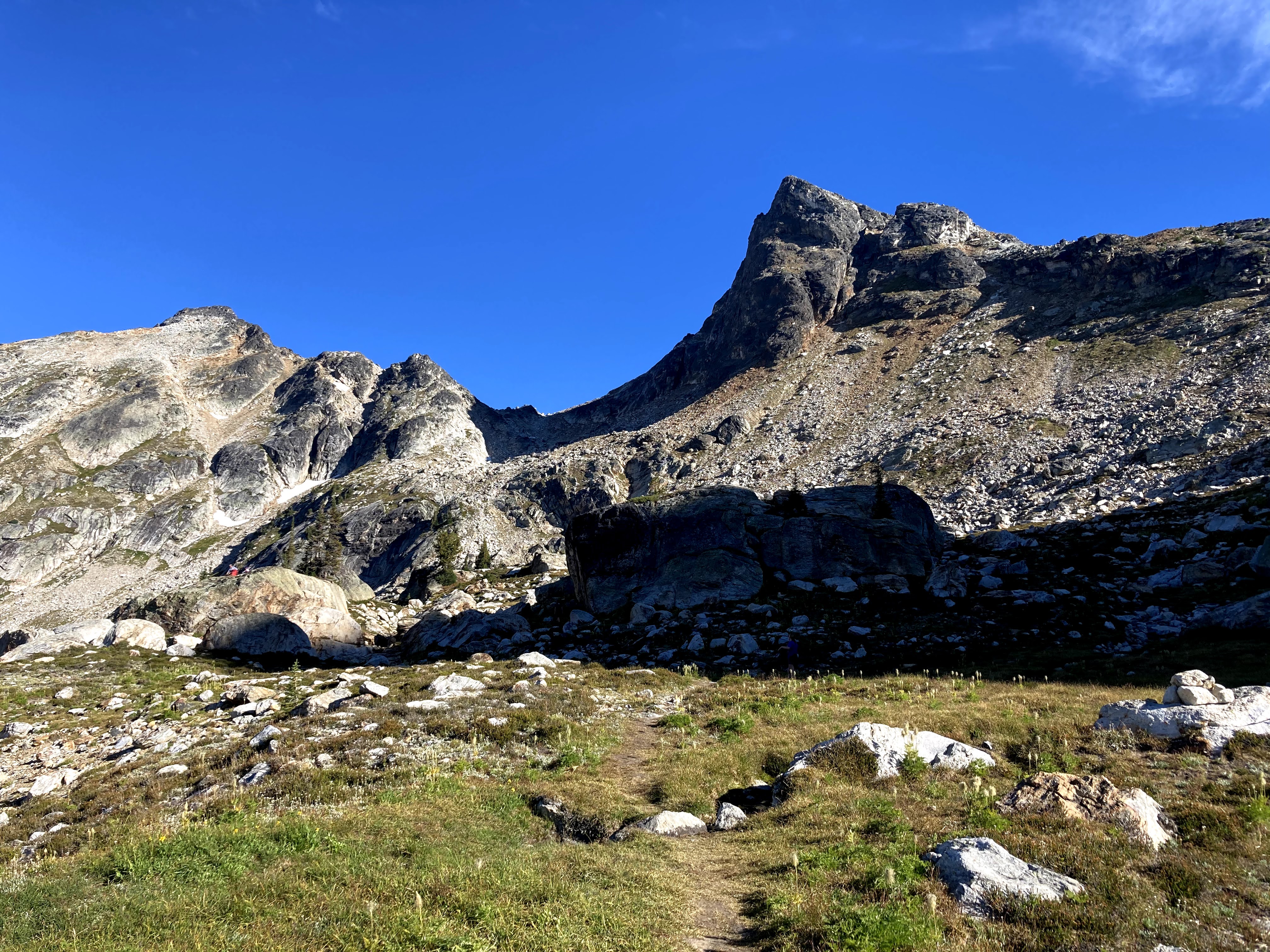
Above: Black Prince Mountain (left) and Lucifer Peak (centre) viewed from Gwillim Lakes
Below: Lucifer Peak viewed from Black Prince Mountain

Let's begin with a map overview, and then we'll get into the trip. There are two red paths, the one from the parking lot to Gwillim Lakes was recorded on the way back on Day 3, and the path from the lakes to the peaks was recorded on Day 2.


Day 1
Let's start at the parking lot. I had read lots of stories of people leaving their vehicles overnight and porcupines chewing the brake lines and tires and leaving them stranded when they get back, so I was not going to take any risks! The solution that hikers around here employ is to wrap their vehicles in chicken wire. Getting my vehicle all chicken-wired up took about a half hour. A group of incredibly nice Japanese women parked beside me and they were a little short of chicken wire so I was able to give them some that I had spare. They had driven all the way from Kelowna that same day, and we had a very nice (albeit short) chat.
I started off near the lower parking lot at around 1pm. Here was my sketchy jerry-rigged backpack. I was packing my Osprey Farpoint 40L backpack the night before, and it became clear that I would have to pass on bringing my waterproof jacket, and the sleeping pad was also not strappable anymore, as the backpack was completely full and the straps wouldn't go. All I had in it were some clothes, food (no mini stove or anything), and essentials, so shedding weight was not a possibility. For food, I had a couple of apples, bagels, peanut butter, trail mix, and granola bars. My food bag was the zippable bag that foldable camping chairs go in (lol). I used a SUV cargo net and strapped it to my backpack, threw in the sleeping pad and some clothes (wrapped in a plastic bag), and off I went (left ~1pm).


There are a lot of big potholes on the road between the lower and upper parking lot, and the road is in horrible shape with lots of big protruding rocks. Although I saw a few SUVs at the end of the trail, I did not regret my decision to hike an extra 30min.

I got to the top parking lot and trailhead around 1:30pm. I noticed there was quite a bit of spare chicken wire in the corners. Onto the trail!


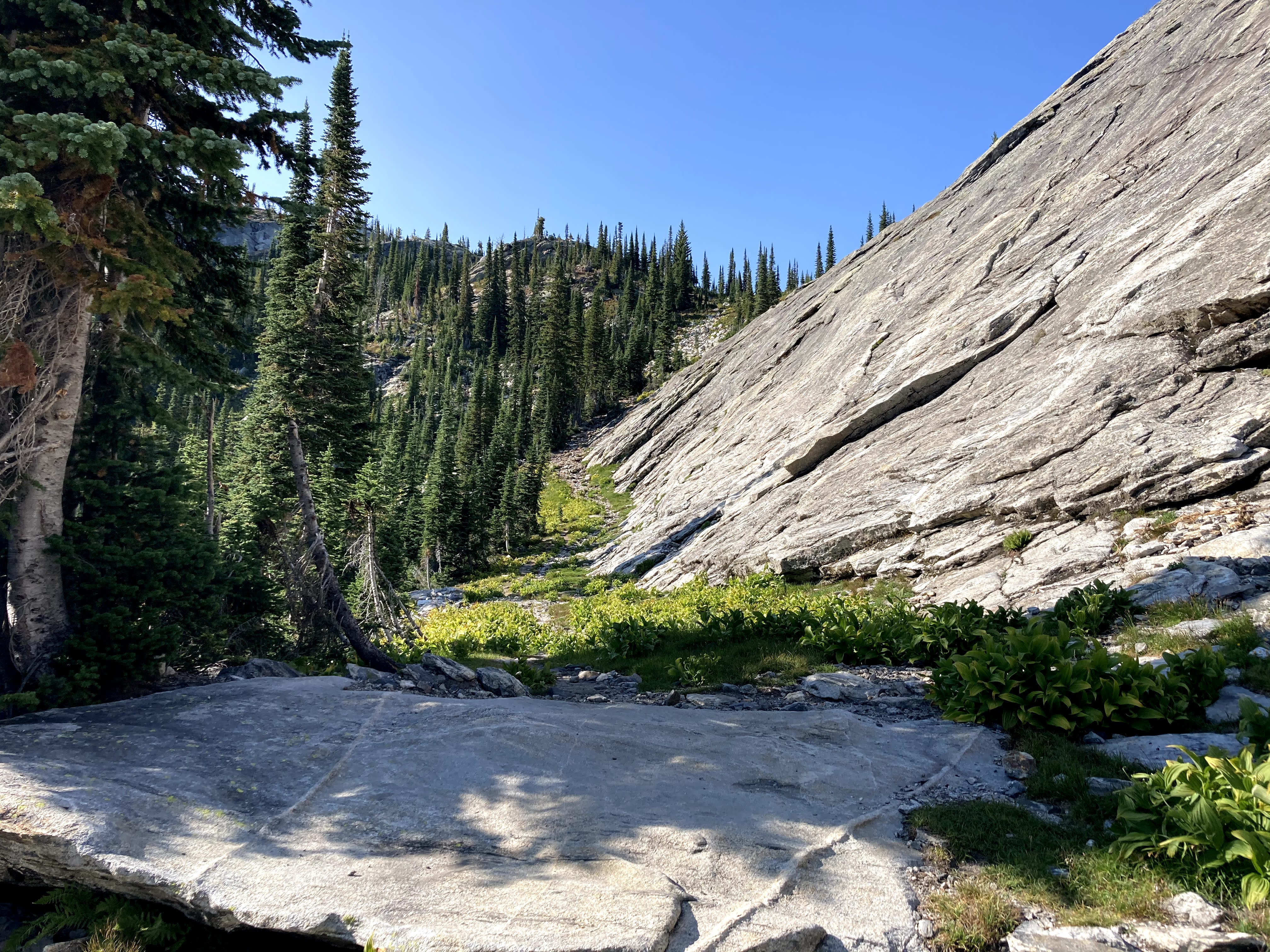
Eventually, I got to a little boulderfield (picture below taken around 2pm). You can see the path going forward on the far right in the first picture.


By 2:20pm, I had reached Drinnon Lakes. My water bottle was at the bottom of my jerry-rigged backpack, but I was able to get out some water and refill here.

I came across another lake (might be unnamed). Got a really nice panorama here, and you can see Drinnan Peak on the center-right side.

At 3:50pm, still chugging along. The second picture below is looking back.

My very first glimpse of Lucifer Peak at 4pm - I was at Gwillim Lakes minutes after (2.5hrs from upper parking lot, 3hrs from lower parking lot).

The campground was totally packed, and it took 10min just to find a spot! I found a spot in the far corner on a flat patch of grass, and put my stuff down. I had a nice supper (12 grain bagel + peanut butter) while sitting by the water.

I got back to my stuff, set up my tent, and was able to relax for the evening. I am really used to day hikes where efficiency is key and I need to quickly get in and get out, so I'm still learning how to "relax" on these trips. I explored the campground a little - there are metal food caches on the west side, and two conveyor belt outhouses - the pinnacle of pooping technology! Later, I got some nice alpenglow pictures, check them out (~7pm):

Walking a little bit in a southeasterly direction, I got a nice view of Drinnan Peak (the highest peak in the picture), Asgard, Midgard, and Gimli. Gimli is the one peak I had already done in the Valhallas - you can see it in the distance, just to the left of Drinnan in the picture below.

I went to bed fairly early (maybe 8-9pm?) because I was absolutely exhausted. I was looking forward to the scrambles!
Day 2
After another peanut butter + bagel breakfast, I started hiking a little before 9am. I ran into the Japanese women again - they were planning on doing Lucifer, and we chatted about potentially trying to simply go on the west side of Lucifer and bag both easily. From my reading, I was pretty sure the west approach of Lucifer was a straight up rock climb, but in my heart I was hoping it would be doable - I didn't want to have to summit Black Prince and have to go all the way to the east side of Lucifer to make the approach.


I came up to a really nice rock shelter that had an excellent panoramic view of the lakes. I had a little break here and then continued.


In the picture below, I scrambled up and to the right. This was definitely about as hard as the scrambling got. On the way back, I didn't follow the exact same path and I had to go really slow because the path I had chosen had much poorer hand/foothold choices.


The scrambling from here was pretty fun. I'm sure I could have taken an easier route, but I enjoyed maneuvering around big rocks.

I was at the tippy-top of Black Prince Mountain at last (15min before noon). Check out the video!


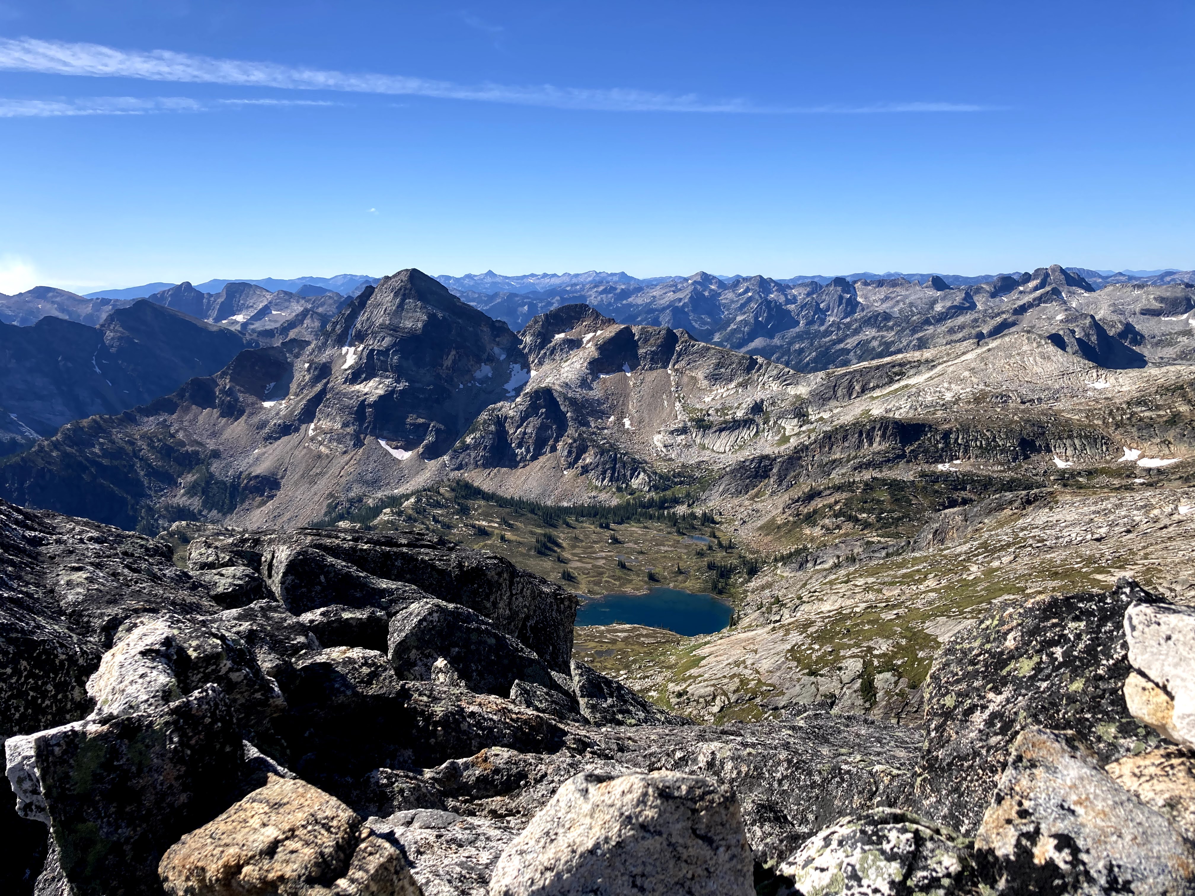
There is an absolutely magnificent view of Lucifer and some of the surrounding mountains! It's pretty clear why the west ridge is not scramble-able - that ridge is steep as heck! Note that you can see Asgard, Midgard, and even Gimli (3rd from the far right) in the picture below.
I started the trek back down the mountain. It really is crazy how long it takes to boulder hop - getting to the east side of Lucifer took me almost three hours (including breaks)! I finally finished the long trek to the east side of Lucifer at ~2:50pm.


Below, you can see a couple of mountains in a somewhat north-easterly direction (if I recall correctly).

If I remember correctly, the main route goes around to the left, but I decided to go straight up the steep incline pictured below (~3:20pm).


I got to the crux at 3:40pm. It doesn't look that exposed in the photos, but there is an incredibly steep drop on both sides. It isn't too challenging, but the exposure definitely had me gripping the rock really tightly. On the way there, I stepped on top of the rock and then jumped down, but on the way back, I stuck my boots into a tiny lip in the bottom of the rock and shuffled and made it through.

Maybe this shot shows it better: You have to use the middle rock and there is a steep drop on either sides. You have to make it across the big rock at the top and then jump down to the little flat rock in the middle.

I got to the top of Lucifer shortly after. Here is a panorama, with Black Prince Mountain on the left side in the first picture.


I signed the summit register (my first signing!) and after getting some nice shots and a video or two, I headed down. Unfortunately, I was out of water and was also pretty exhausted - I was definitely slowing down. The picture below was taken around 5:40pm, when I was able to find a stream and filter some water.

When I got back down, I found that quite a few tent sites had opened (makes sense, as it was Sunday night), and I quickly moved my tent over to one of the primo "wooden plank" tent sites. I struggled to secure my tent well on the wooden planks - I asked a couple of people nearby, and they said they just put rocks inside their tent, so I tried this strategy, and also weighed down the tent fly with rocks, but slight shifts and strong wind gusts would made the rocks shift slightly and the fly would begin flapping in the wind. I had to find bigger and heavier rocks, and it was a little annoying. Eventually, a guy with a big DSLR named Bev walked by my tent, and I told him it was my first time doing an overnighter solo, and he offered to help me out. He spent a decent bit of time helping me secure the tent using some rope I had and the little rope things that are attached to the fly. It turns out he was a retired teacher from White Rock, and we had a nice conversation about his teaching and he offered me some life advice. He said he was going to send me some of his pictures of Lucifer and Black Prince, but I think he forgot - it's too bad, as he was carrying a really nice DSLR. Here's a picture from around 7:30pm - you can see that it is getting quite cloudy!

I went over to the food caches to have a final snack and call 'er a day, and I ran into a really nice couple (Danny and Ashton). They were a little worried because they didn't bring their water pump, and I talked to them about water sources, and then we got chatting. It turns out we were all from Alberta (I think one of them was from Peace River, and maybe the other from Edmonton). Danny was doing an MSc. in Chemistry at UBC, and Ashton did something with entomology and plants. We had an incredibly pleasant chat about college, COVID, and life! It got quite dark, so I headed back to my tent, and as it was getting quite chilly, I hit the sack.
Day 3
It wasn't a great sleep. I lost count of how many times I woke up in the middle of the night because it seemed like every time I closed my eyes the winds would pick up and rattle the entire tent until it seemed like it was going to fall apart. It also got quite cold - my (fairly cheap) sleeping bag was rated to 9°C, and I was incredibly thankful that I had brought my jacket in my jerry-rigged net-backpack.
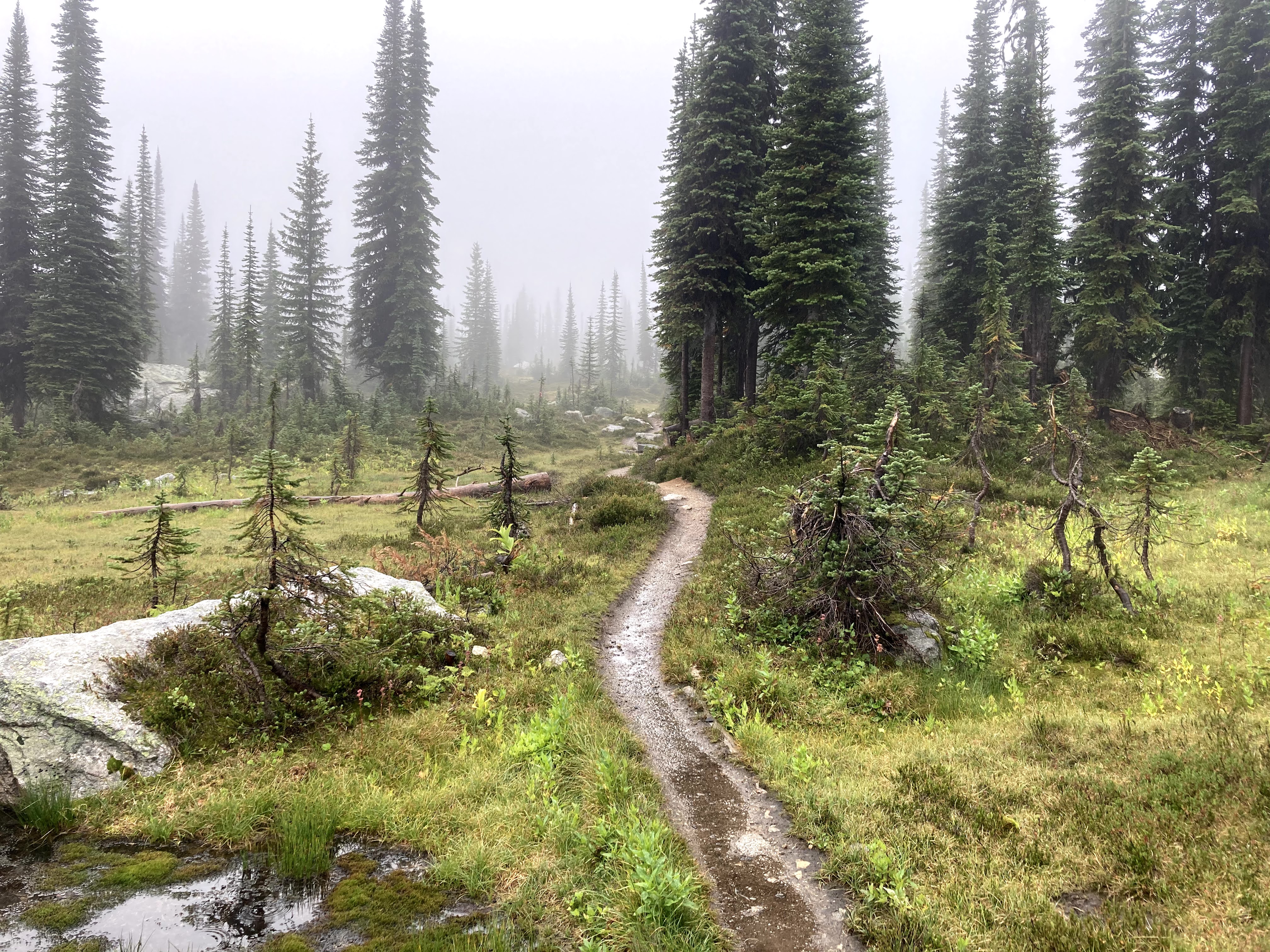
I set my alarm for about 5:15am the next day, but I was tired, sleepy, and a little cold so I stayed in bed until about 5:40am. The winds were still pretty strong. I began to pack up my stuff, but the winds made it really hard to roll the tent and such. It started hailing around 6am, and this added to my troubles. I couldn't pack my stuff well because my hands were freezing cold and I was being pelted and hit by strong winds, and I thought about just waiting for it to blow over, but instead I got the heck out of there ASAP (did not even eat breakfast)!


The one downside of having the net-backpack is that I was worried something was going to fall out so I took it off and double checked that it was secure every 30 minutes (lol). The going was a little slow, as I did not want to risk slipping on a wet surface.
I stopped at Drinnon Lake for a peanut butter bagel, and then kept moving forward. Fortunately, there was a couple (Laura and Mer from Nelson, BC) who were wrapping up their hike at the same time, and they gave me a ride back to the lower parking lot where my vehicle was parked. I started driving back and saw at least 30 downed trees on the drive back to Slocan. There was one spot with about 9 downed trees in the same little area, completely blocking off the road! I had to stop for maybe a half hour and help people move downed trees (a fellow with a chainsaw was going at them hard).

Looking back at the year, I am incredibly happy with what I have been able to accomplish. I summitted 14 peaks, some of them decently challenging and/or exposed, and I did my first solo overnighter (something that had been on my list but had been put off due to time/budgetary concerns).
Here are some of my highlights:
- Favorite scramble: Gimli Peak
- Out of all the scrambles I did this year, Gimli gave me the biggest thrill. The exposure was next level compared to what I was used to at the time of doing it. Looking back, it feels like the most exposed hike I have done this year, although it is possible my lack of exposure to exposure (lol) may have made it seem worse than it actually was.
- Most picturesque scramble (i.e. best views): Lucifer Peak and Black Prince Mountain
- This was my most "backcountry" hike, and the panoramic views were incredible. I find there's something nice about having water bodies nearby that makes mountain pictures feel more complete.
- Most stressful scramble: Coquihalla Mountain
- I got back to my car at 8pm after spending quite a bit of time lost and unsure of how to get back to the main part of the mountain. It started to snow and got incredibly windy, and at one point it seemed like I would have to bushwhack a few kilometers, although it ended up being only metres of bushwhacking (the trees blocked a lot lol).
One thing I've learned about myself is that I really enjoy exposed scrambles. I used to be incredibly afraid of heights, and although I'm able to "turn it off" when I scramble now, I do wonder if this fear is the reason why I get such a thrill out of exposure! It's gotten to the point where I simply don't enjoy non-exposed hikes anymore (I often appreciate them more for company, if I have some).
What a year - 14 peaks, hail, snow, getting lost, finding the path again, and chugging along hike after hike! Although this hiking season has come to an end, I am looking forward to more peak-related adventures in the next year. So long!


Comments
Post a Comment