This was by far the most technical (and also one of the most fun) scrambles I've done to date. I was asking around for more technical scrambles in southern BC on the ClubTread forums and @rhinolady recommended a traversal of Coquihalla Mountain. I started doing some research on the mountain online, and I found that it involved Class 3-4 scrambling. I had been searching for more Class 4 scrambles because I wanted to be able to improve and complete more technical scrambles. I saw that quite a few people had done Jim Kelly Peak and Coquihalla Mountain in one day, so I figured I might as well try to bag both.
Distance: 23.0km (according to TopoMaps+ app - includes me getting lost)
Elevation Gain: 1507m (according to TopoMaps+ app - includes me getting lost)
Above: Jim Kelly Peak, viewed from Coquihalla Mountain.
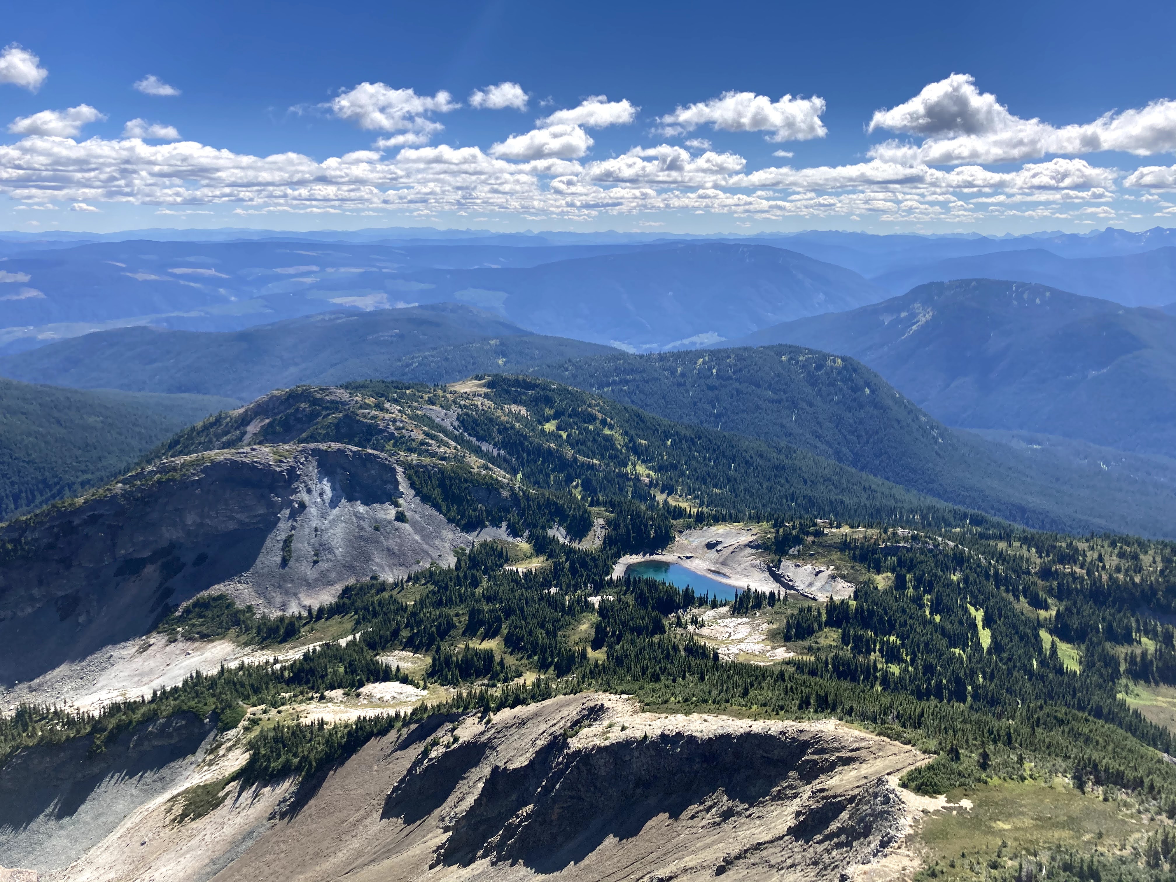
Below: Coquihalla Mountain, viewed from base of Jim Kelly. I made it up to the top of the peak you see in the picture, but it is only the false summit.
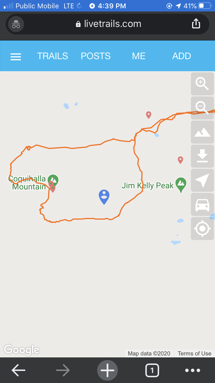
Here is a bit of an overview of the path I took:
As you can see, I was a little short of the true summit. What happened was that I made it that far and I was just certain that I had reached the true summit (you can only see the false summit during most of the hike), and I saw some footprints on a gully looking south and was certain that this was the path on the south I had read about. I could have easily just downloaded a "gpx" file and followed the south ridge route using someone's tracked trip, but did I do that? NOPE! This is my first summit with an asterisk on it, and I am a little frustrated because I reached an elevation of 2115m and the true summit was at 2157m, and as you can see on the picture, all that was left was a simple ridge walk! I was so incredibly close but I just assumed I had hit the true summit and then headed down. I talk about this all again at the end of this post. In the second picture below, you can see someone else's track (found it online), where they chose a longer but easier route - through the north/northwest and south ridges instead of the northeast ridge.
On to the hike: getting to the parking lot was not hard - I approached from the east (Princeton and the town of Tulameen). It was a rocky, rough road, but there were no bits that seemed to require lots of ground clearance (although it would certainly be nice to have some) - in fact, when driving there that morning, I saw someone coming back in a Nissan 4 door sedan. Clearly, you don't need a jacked up truck to get there.
I started off at the parking lot at 8:15am. There were quite a few cars parked, pretty much all seemed to have been there overnight since they had a layer of frost.
The trailhead / continued forest service road is right on the parking lot.
Someone made it a decent bit through in a fairly compact SUV (picture taken at 8:40am). The FSR is pretty rough in the section past the parking lot, and the last bit (past this silver SUV) would definitely require a truck I think.
At the very end, I saw a large Toyota truck, so you can make it all the way to the end of the forest service road if you have enough ground clearance and are willing to risk some scratches. I didn't keep track of how long it took me to get to the forest service road on my way in, but on my way out, with tired legs, it took me 35min to get from the end of the forest service road to the parking lot.
Starting to move away from the rocky path to a dirt forest-y path.
Back onto some scree by 9:40am (~1.5hrs in).
There were an absolute crapton of wild blueberries along the trail. I stopped for 10 minutes and ate a big handful. I really wish I had one of those blueberry rake things and a couple of plastic containers so that I could keep some for later!
The first picture below was taken around 10:15am. I didn't wear any bug spray and I did not encounter any horseflies or mosquitoes during this entire hike - it was a pleasant walk!
Around 11am, I took the following picture looking back:
I was eying Jim Kelly and saw a little shortcut - you can see a little path in the scree where someone has tried to take a shortcut and it seems like they were able to avoid going around to the other side of the mountain to start the ascent. The scree was fairly loose, so I started veering towards the green tree/shrub things on the top right.
I stopped at the shrubs for a short water and cantaloupe break. I started going upwards, and I met a couple who said they had camped in the area overnight and had tried to make it up Jim Kelly but could not find a way up - they came up to a vertical climb and then headed back. As always, this concerned me a little, but I trudged onwards. The scramble up Jim Kelly was fairly easy, no technical moves and not really any serious exposure either.
Looking back, you can see Coquihalla Mountain. I climbed the left (false) summit in the picture below. I'm fairly certain the true summit was the one to the right behind the false summit.
I got to the top minutes before noon (~4hrs from start). Here is the "famous" toppled over cross and all the guy wire that failed to hold it up.
The sun came out and the lake to the south looked beautiful!
I only meant to stay here for 15 minutes, but I ran into another hiker who finished his scramble shortly after mine, and we got chatting. He was a really nice guy in his mid-fifties named Craig, who worked as a steel worker in Mission, BC. He told me he had a friend who had done Coquihalla Mountain but that it was a really challenging scramble, which made me concerned (didn't end up being too bad though). We hiked down Jim Kelly together (started heading down at ~12:30pm), and it was enjoyable! The second picture below was taken at around 1:10pm when I was down the mountain.
I followed the left path in the fork below.
Took another left in the picture below to start heading down towards Coquihalla Mountain. For Coquihalla Mountain, there are three main approaches that I had read about:
Northeast ridge (Class 3-4), supposedly the hardest but most direct approach (my approach)
North ridge (Class 3)
South ridge (Class 3)
My plan was to go up the northeast ridge and then either return by the same ridge or return from the south ridge if a return from the same ridge seemed too sketchy (going down is hard!).
The scree here is pretty loose. It wasn't too fun, but didn't take too long to get through. The first picture below was taken around 1:20pm.
This is where the real scramble begins. The tricky part of scrambling this mountain was the fairly loose rock - you can't afford to forget to check a handhold. Right now, the worst part of looking back at pictures is that I can't even tell where I went - the rock all blends in, and so there is poor depth perception, but I think I went up and right in the picture below. The pictures below were taken around 1:30pm.
The first bit is near vertical. I was pretty sure I did not want to return down this route, and was getting a little worried, because I really did want to go up the whole mountain like this.
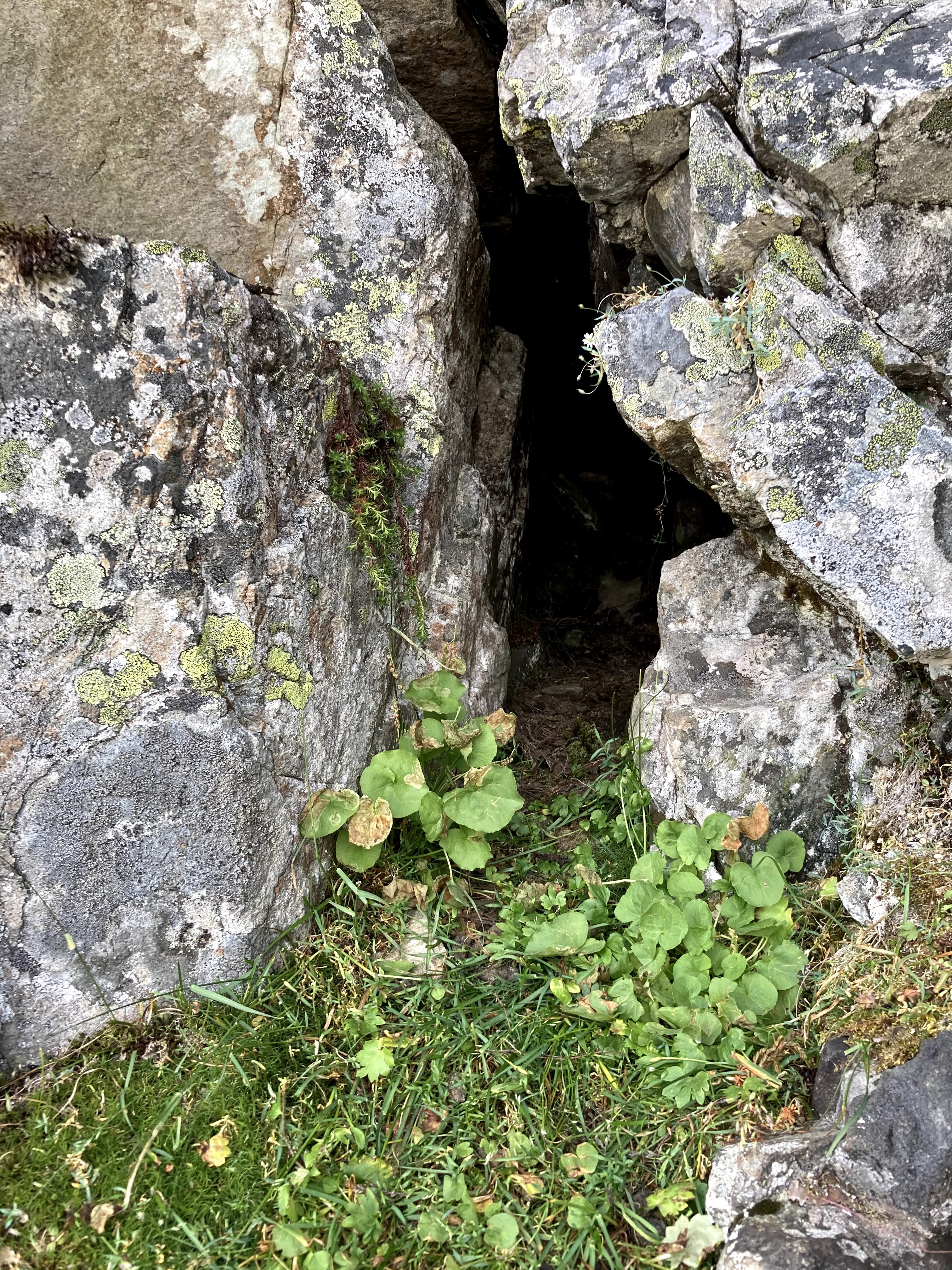
I was looking for a way up and got a little stuck. Straight ahead of me was this little hole (didn't see any inhabitants)!
The angle really doesn't tell you much, but it was practically a vertical climb when I looked up, and I was not confident that I could get up safely (see picture below). You can see a missing rock there - I was going to use it as a handhold but immediately found that it was incredibly loose and just about to fall. I sort of just moved out of the way and gave it the lightest tug to let it fall. I'm not sure what the best step really is - on one hand it seems like I'm accelerating the erosion/weathering on the mountainside, but on the other hand, I'd rather have the rock in pieces at the bottom of the mountain than falling on somebody on their way up.
I was really debating turning back, and then when I looked behind me, I immediately saw that I had missed the path going off rightwards (pictured below). Silly me! I had to be a little careful with my holds when I was crossing the gap to get to the little flat rock at the bottom of the picture, but it wasn't too bad.
Finally! I was done the hardest bit of the scramble and now what was left was mostly Class 3 scrambling and walking on the "knife" edged ridge (which was not as knife-y as it appeared). The picture below was taken around 2pm.
Below, you can see the Flatiron, Needle Peak, Vicuna Peak, and Yak Peak, all of which I have summitted. It felt great to be able to look out and see the peaks I had bagged. Hopefully I can check out some of the other ones in that picture one day!
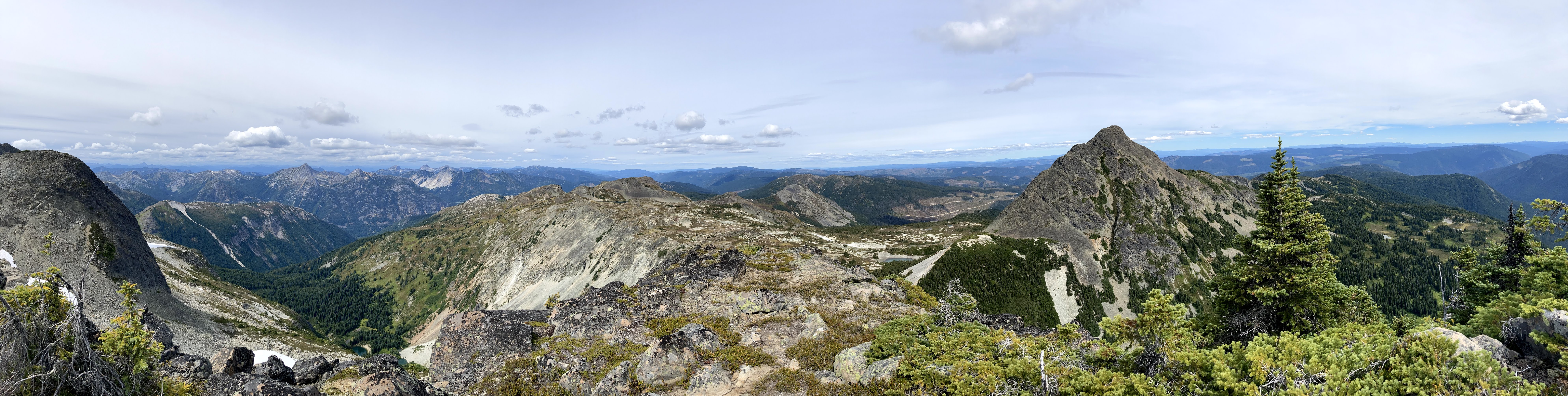
The scramble from here was all Class 3 and pretty fun:
Check out the below picture - it's pretty likely that there used to be a giant rock here that eventually became loose and fell off. Given the size of the "hole" it left, I'm glad I wasn't in the area when that thing fell. Loose rocks are definitely pretty common on this scramble. Somewhere during this hike (before I got to this point), I was coming up and tested a handhold on a giant rock (I can't tell how much it weighed, but it was easily 50-100lbs), and immediately it shifted forward, and I knew that if I let it go it would fall down and pulverize me. I had to support it for a few seconds and then yeet out of the way as it fell. This whole experience really surprised me since I had never had that happen before. It's a little concerning, because a rock of that size would really make you fall back, and falling back = death on scrambles like this! It was a good reminder to always check handholds.
I finally got to the ridge! You can see Illal Peak nearby - it is the somewhat flat-topped peak slightly left of center.
Now begins the "knife" ridge climb. It's almost a walk but I used my hands a lot just to be safe, and for the most part I stayed a little on the right side of the knife. The picture below was taken at 2:30pm.
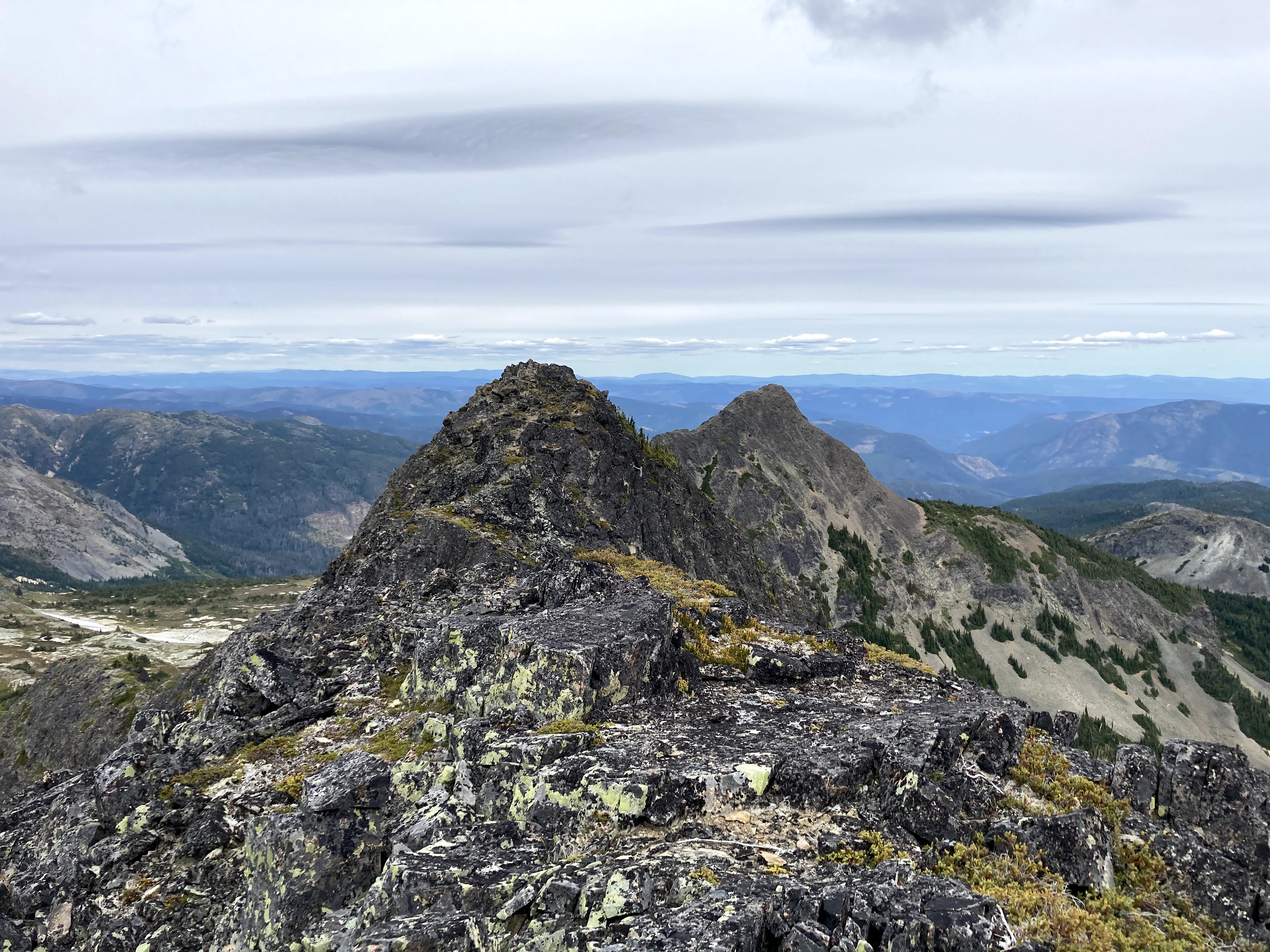
I made it to the top of what I thought was the true summit and had a good meal and break there (2:45pm-3pm). On the right in the picture below is what seems to be the actual true summit (my summit failure is discussed more later on). It seems pretty obvious that it is the true summit in this picture and looking at this brings me a twang of pain as I am reminded of this failure.
Looking back, you can see the false summit I climbed and Jim Kelly Peak in the background.
On the other side, you can see the true summit of Coquihalla Mountain.
I saw footsteps in this little gully thing, and I thought it was the way down so I followed it. Hint: It was not the right way down. The scree was incredibly loose and it took forever to get down safely. I started at around 3:10pm.
Lookng back up from where I came in the first picture below. Second picture is looking down (obviously!). Third picture was taken at 3:50pm.
I'm pretty sure people don't ever use this route to go down. I think people just check out the top bit of the gully and that is why I saw footprints. You can see the true route someone had taken at the start of this post.
Now - for the return to the point where I started my ascent of Coquihalla: it really seemed like people had made lots of paths along the mountain - there was crushed vegetation, dirt that had been stomped on, etc. However, these paths didn't seem to be consistent - I would see a little bit and then it would end. At this point it started lightly sprinkling rain. I was trying to find a way down and then I was able to get a signal and find a route someone had done online (they avoided the northeast ridge I used) and I quickly learned that I was waaaayyy off.
I had to do some bushwhacking and then I got back to scree. I'm really gonna skip a lot of the details here - the gist is that I was pretty lost, had to do some sketchy scrambling to get down, and it was super slow since I got kinda far from any reasonable path.
I got back to bushwhacking and was getting a little stressed, but I saw a dropped Bic lighter, which gave me confidence since it meant someone else had made it through too. I picked it up (gotta pick up junk if you see it!) and headed onwards. Luckily specific little bout of bushwhacking only lasted a couple min. The picture below was taken at 5:15pm.
It was starting to get really cloudy, and the rain had started to transform to snow. It was getting cold and dark and I was getting a little concerned. Eventually I made it back to the base of Coquihalla.
I got back to the lake by Jim Kelly Peak, and quickly had a little bit of filtered water from the lake before heading off again. I was pretty thirsty and I also was feeling a little hungry but I was in a rush to get home so I didn't quench either desire. My hands were really cold and the snow wasn't too bad but the accompanying winds were really not fun. I had checked the forecast that morning and the forecast was partly sunny - no mention of precipitation. I wore my hoodie for that reason, but I wish I had worn my waterproof windbreaker. Note to self: prepare for the snow in the future!
The way back, I ran any straight sections that I encountered but I didn't want to hurt myself by trying to run where it was not simple and straight. I was wearing sweatpants and they got drenched, both by the rain and the vegetation that would brush them and drop water on them as I walked through. I could feel the water dripping down my leg into my boots. My boots were full of water and I heard the squishy water noise every time I took a step - it was really kind of miserable. I'm used to entering dry regions and leaving them dripping wet but this was too much for even me.
Just kidding about the last one. The last hour of hiking felt like an eternity - each step hurt and it was not pleasant at all. I got back to the parking lot at 8:15pm (12 hours from the start time). I was incredibly exhausted. There was no one left in the parking lot.
I am incredibly sad that I didn't make it to the true summit of Coquihalla Mountain. However, I am counting it as a summit on my summit map, even though deep down it feels like I'm lying. I got to about 2115m of the 2157m mountain, and the rest of the way would have been super easy walking/scrambling on the ridge. It's quite annoying because I was able to push myself and do the more technical northeast ridge but missed the easy part. In hindsight it is pretty obvious that I had not reached the true summit (just check out some of the pictures), and this is the source of further frustration. However, I'm trying to look at it as a lesson:
If there is a downloadable "gpx" file (as there was in this case), I will download it so that I can see where I am and where the trail is as I go along.
I will save the true summit as a landmark on my phone while I have service so that I can know if I have reached it. Or I could at least check out the geography of the area on Google Earth beforehand to know what the route will look like in 3D.
In a way, getting lost and coming down early was a good thing - the scramble on the far ridge coming down isn't supposed to be sketchy, but I'm sure the rain would have made it a little harder to grip the rock. Coming down earlier was certainly safer.
The one good thing about making a mistake like this is that I'm pretty sure it won't happen again. The pain of having to put an asterisk next to a summit is simply too great.
Despite the false summit mishap, getting horribly lost, the miserable and painful walking while drenched, I would still call this trip a success. I know for a fact that I would not have been able to do Coquihalla Mountain at the start of this hiking season, and it is great seeing myself improve and become more competent/confident in this regard. The scramble up Coquihalla is easily among my top two favorite scrambles!
I was looking at hikes in Valhalla Provincial Park, and Gimli Peak immediately caught my eye. The fourth highest peak in Valhalla Provincial Park, it is popular with climbers, and there is a Class 3 scramble up the east ridge. Although there is plenty of information about the climbs online, I didn't find much information about the scramble. I am happy to report that it is an incredibly rewarding hike/scramble, and the panoramic views at the top of Gimli Peak are definitely worth the grind. I think Gimli Ridge could be skipped in favour of Gimli Peak - the only thing you get from Gimli Ridge is a slightly different angle of more limited views, whereas Gimli Peak provides a beautiful 360° view. Both are nice though!
I was planning one last trip of the season, and I wanted to do an solo overnighter, and after some deliberation I decided to go to the Valhallas again. Holy crap did I make the right decision! Lucifer and Black Prince are well worth the trek. The views were spectacular, the peaks were peak-y, and I met many a fellow broski on my journey! I also made it through a fairly sketchy backpack situation and a decently big storm.


Thorough and well-written! Bon!
ReplyDelete