Vicuna Peak
Vicuna ended up being a little more challenging than I expected. The trudge up to the saddle was not too bad, but the scramble at the summit ended up being more exposed than I expected. The scramble was mostly Class 3, with one Class 4 section that was definitely on the edge of my comfort zone. My initial plan was to do both Vicuna and Guanaco, but we started rather late (11:30am-ish), and even after deciding to skip Guanaco we only got back to my car around 7pm. I feel like if I had done Guanaco it would have gotten rather late, and I really do despise driving through the mountains that late at night.
Date: Jul 26, 2020
Park: Coquihalla Summit Recreational Area
Name of Hike: Vicuna Peak
Mountain Range: North Cascades
Elevation: 2126m
Distance: 18km (based on a look at the AllTrails map)
Elevation Gain: 1km-ish (AllTrails has Vicuna and Guanaco at 1.2km, so this is a guess)
Total time (including several breaks and the portion of time we were lost): 7.5hrs
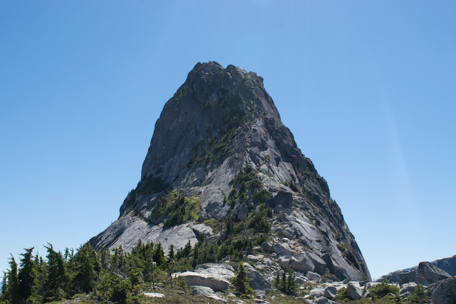
Above: Vicuna viewed from the saddle
Below: Needle Peak, Flatiron Peak, and various other peaks from Vicuna
This hike is technically outside the Coquihalla Summit Recreational Area (CSRA). I know that AllTrails lists it under Zum Peak Recreation Site, but when I checked the boundary of that site, Vicuna lies outside of it, so I'm not sure how to categorize it. It's close enough to CSRA that I feel comfortable just calling it a CSRA hike.
There are basically five stages of this hike:
- Flat 5km walk on the Forest Service Road (FSR)
- Straight uphill on dirt path
- Really muddy section
- Standard "leaving treeline" trail (including small boulder field)
- Standard scramble but with sketchy Class 4 crux
Let's go through the hike day:
I had parked in Hope the previous night and I slept in my car. I can't fully straighten my legs in the car that I currently drive so it really isn't a great sleep to begin with, but then at 1am I felt a bright light on the vehicle and heard a man and a woman talking. I heard something like "It does have BC license plates," and prayed they would just leave me alone but one of them said "Try shining a light in the vehicle." I was shirtless and half in a sleeping bag and I felt the blinding light on my face and I sort of just covered my eyes but fortunately I heard a "Oh there's someone sleeping in there - Sorry" and they left me alone. I really don't understand why they were walking around at 1am with a flashlight and decided to approach my vehicle which was parked between a park and industrial area with no sidewalk or walking path nearby.
I read on AllTrails that you should take Exit 228 and not 221, so I sort of just followed their advice and I met my companion in the rest area shortly after taking that exit. There are EV parking spots and flush toilets and decent bathrooms at this rest stop, which I was grateful for.
The drive from the rest area to the "trailhead" (in quotation marks since you have to walk another 5km before you get to the true trailhead) is not smooth by any means. I would not feel great having a low clearance vehicle on that trail. A Honda Civic would not do great - lots of potholes before the "trailhead" and if you want to go further and minimize the walk (which two cars did), you definitely can but you risk scratching your vehicle up pretty badly, not to mention the physical beating the car may take.
We started the actual trail after 11:30pm (I didn't record the exact time unfortunately). You start off by crossing a vehicle bridge. The first 5km are rather boring - I wish I had a bike mount for my car because the mosquitoes were insanely bad on the way back.
There are maybe three or four areas with some creeks but only two of them are deep enough to warrant watching your step (provided you are wearing good Gore-Tex boots!). I had to throw a few big rocks in to make one of them easier to pass.
At the end of the FSR, I took a hard left at the little rock-stick inukshuk, and immediately crossed a small (6ft long) wooden bridge. (I think this was around 12:30pm?).
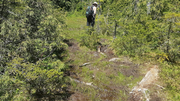
Then, the uphill part begins. The trail has a decent number of markers, and is fairly trodden, but there are a few sections with enough large sticks and debris here and there that I found myself questioning whether I was off the trail. We found the elevation gain fairly strenous and stopped for breaks a couple of times. We also briefly went off trail. We saw three fallen trees on the left and went straight instead, but the trail actually goes through the fallen trees (pictured below)!
We were off the trail for maybe 20min or so - my companion tried walking along some granite that ended up being wet, and he fell and slid about 10m and scratched up his arms decently badly. We kept on going up, and eventually the tree cover diminished and we were in a muddy grass section (photo below taken at 1:10pm).
The muddy section is really no more than a half hour. I am so glad I finally bought hiking shoes because on two occasions the mud gave way and I pulled out my boot to see that it had mud all the way up to just below the ankle. Hiking in running shoes would be hell on a hike like this.
My photo timestamp shows that we were in the boulder field at 1:30pm. There was one boulder in particular that caught my eye - it looks like someone has carved steps into this boulder although I read somewhere afterwards that it is natural (not carved)! I should have taken a photo of the entire thing but I only got the top steps.
The trail starts to curl around Vicuna to the saddle between Vicuna and Guanaco. There was one spot with lots of snow right along Vicuna's granite face and a small stream where my companion and I refilled our water bottles. You can see Guanaco on the right in the picture below.
There was a grassy bit, and then we got to the saddle around 2:40pm. The panoramic view is really quite nice.
We enjoyed a nice lunch at the saddle. The mosquitoes were fairly bad and we spent a decent part of our break slapping skeeters. Around 3pm we left our poles and bags (except my camera bag!) at the saddle and started making our way up. Overall I think the scramble wasn't too bad but the one Class 4 section was pretty exposed. I think what made it a little freaky for me was the fact that the first "rope" did not look very grippy and I also couldn't even see where it went and what the next step would be - it just seemed like a vertical climb. I'm glad that my companion was with me - I find that seeing someone do it first or having someone alongside is nice for the sketchier bits. We saw maybe 7 people that whole day and no one on the actual scrambling section until our way down, so if I was going solo I would have some hesitations. I think there's a decent chance I would have still done it but it would have been very slow and careful.
I didn't take any pictures of the rope coming up but I got a few coming down. First, there is one thin metal rope with a plastic liner that is attached to the mountain with a bolt. This "rope" has small metal locks instead of proper knots and I was pretty worried about my ability to grip it well, but it didn't end up being too bad. As soon as I grabbed the proper rope I felt a lot better - the grip is much better, and there are actually two ropes so I felt even more confident. Coming down, I realized the entire rope section wasn't too bad but as I mentioned before, I think a large part of the perceived difficulty was the fact that I couldn't see beyond the metal rope and that it just looked like a vertical climb from the angle. You can see the two rope section in the first picture below.
The view at the top really is quite spectacular. Undoubtedly among the better views I've gotten in my hikes thus far. The only annoying thing was that the mosquitoes were not much better at the peak and I was getting devoured left and right.
Neither of us were really feeling Guanaco at this point so we headed back down. I was really slow coming down on the rope but I'm sure I will get quicker with more experience and confidence with this kind of exposure. We got back to the saddle around 4:20pm (roughly 5hrs from our start) or so and headed down. I fell once in dirt and my companion fell in mud, but we got back to the proper trailhead safe and sound. However, in the 5km between the proper trailhead and where we parked our cars, we got absolutely annihilated by mosquitoes. I re-sprayed myself generously along the route but it really didn't seem to help, so I partially jogged the FSR. I got back to my car at 7pm (7.5hrs from the starting time). I think this trail can definitely be done in less time - we chose to stop many times and really took time to appreciate the views.
This hike was definitely worth it. The views were amazing and I am so grateful I was able to go through that sketchy Class 4 bit - I am confident it will help me on my journey to improving as a scrambler/mountaineer. My brand new hiking shoes do not look as brand new anymore though (haha!).


Comments
Post a Comment